
Weather Report
- Blackcomb Mountain
- 2,284m 7,493ft Top of 7th Heaven Express
- 1,860m 6,102ft Rendezvous Lodge, PEAK 2 PEAK Gondola
- 1,545m 5,068ft Glacier Creek Lodge
- 1,248m 4,094ft Mid-Station of Blackcomb Gondola
- 685m 2,247ft Blackcomb Base, Bottom of Blackcomb Gondola
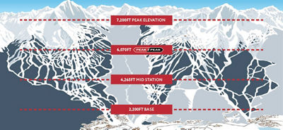
- Whistler Mountain
- 2,182m 7,158ft Top of Whistler Mountain
- 1,850m 6,069ft Roundhouse Lodge, PEAK 2 PEAK Gondola
- 1,664m 5,459ft Chic Pea, Top of Garbanzo Express
- 1,300m 4,265ft Ravens Nest, Top of Creekside Gondola
- 675m 2,214ft Whistler Village


NEW! Young Adults Save 20% on a Pass , opens in a new window
Introducing new savings for adults 30 & under on Epic Pass & Epic Local Pass. Young adults can ski and ride the same world class resorts all season long, now at an even better price.
Plus, Teens can now also save more on access to 90+ resorts worldwide with new pricing for ages 13–17 on Epic Pass.
Don’t Miss These Upcoming Events

Whistler Summer Concert Series


Stay Ahead with the Latest Whistler Weather and Snow Conditions
Check real-time updates on snowfall, base depth, and weather patterns at Whistler Blackcomb. Whether you are tracking the Whistler Canada weather for weekend plans or monitoring the Whistler BC weather for your vacation, our detailed snow report ensures you’re prepared. Explore forecasts, snowfall and expert insights on terrain openings and lift operations—to maximize your time on the mountain. Monitor weather patterns and conditions for an exceptional experience.
Whistler Weather and Snow Conditions FAQs
Yes, heavy snowfall, high winds, or extreme temperatures may delay lifts. Always check the Whistler Blackcomb snow report for real-time alerts.
Download My Epic App
Live Webcams and Weather
Lift Line Status and Forecasts
Interactive Trail Maps
Real Time Operational Alerts
View Your Personal Stats
Epic Mountain Rewards

Alpine Forecast Synopsis
Alpine forecast for today: Cloudy with sunny periods and isolated showers. High 10 °C. Wind southwest: 20-30 km/h. Freezing level: 3300 metres. Precipitation: Trace.
Alpine forecast for the week: Mild and partly sunny, followed by a cool and wet weekend with showers and strong southwest winds. Mixed cloud, sunny breaks, and isolated showers continue through midweek with temperatures slowly recovering. Warmer, drier conditions return through Friday.